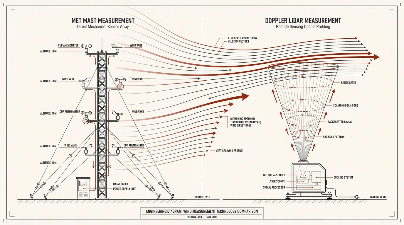
Choosing between LiDAR and a meteorological mast is an early decision with consequences for the wind resource assessment, turbine selection and project schedule. Both technologies can provide valuable data. Their suitability depends on the site and on what the project team needs to establish.
The comparison below concerns ground-based, vertically profiling wind LiDAR for onshore projects. For some sites, the most useful measurement campaign will combine LiDAR and a met mast.
1 Who decides which measurement technology to use
The measurement strategy should be agreed between the developer, the consultant preparing the wind assessment and the manufacturer of the proposed turbines. Each has a different part of the decision to consider.
The developer defines the project objectives, budget and timetable. They also bring practical constraints: land access, existing measurements, site access and power availability. A technically suitable campaign must fit the development programme and procurement plan.
The wind consultant defines the data needed for the report. This includes measurement locations, heights, duration, verification and quality control. They assess whether the proposed configuration can support the wind resource and energy yield assessment, and explain the uncertainty that will remain.
The turbine manufacturer confirms what evidence is needed to assess the suitability of the proposed turbines. Mean wind speed is only part of that assessment; turbulence, extreme winds, shear and flow inclination can also matter. Data adequate for an energy estimate may still leave gaps in the turbine suitability assessment. [3, 4]
Agree these requirements before ordering the equipment. If financing is involved, the consultant should also align the approach with the lender’s technical adviser where required. If turbine selection is still open, review the needs of the shortlisted manufacturers.
2 Is the site simple or complex
For an initial discussion, sites can be grouped into two broad categories. This is a useful screening step; the final classification needs a review of the actual terrain and flow conditions.
Simple sites generally have flat or gently varying terrain and relatively uniform surroundings. Wind conditions are more likely to be similar across the area sampled by a profiling LiDAR. Flat ground alone is not enough: nearby forest edges, buildings or abrupt changes in surface roughness can still disturb the flow. [6]
Complex sites include pronounced ridges, steep slopes, valleys or significant changes in land cover. Wind can accelerate, change direction or become inclined as it moves through the site. These variations affect both the measurement location and how confidently its data can be transferred to turbine positions. [4, 6]
3 Advantages and limitations of each technology
A met mast measures wind locally using instruments mounted at selected heights. LiDAR measures motion along laser beams and reconstructs the wind at several height levels from light scattered back by particles in the air. [1, 5]
| Technology | Advantages | Limitations |
| LiDAR | Measurements at multiple heights, potentially through the rotor till 400m. Compact equipment that can be relocated fast. | Valid data coverage depends on conditions and height. Complex flow and turbulence measurements require particular care. |
| Met mast | Local wind and turbulence measurements with appropriate sensors. Best at measuring turbulence uncertainty. | Height coverage is limited to installed sensors. Structural installation, access and work at height add practical demands. More permits required. |
The advantages depend on the selected equipment, installation and campaign design. [1, 3, 5, 6, 7]
In complex flow, differences between the wind sampled by separate LiDAR beams can introduce reconstruction bias. Flow modelling may help assess and correct it, but the correction needs validation and an uncertainty assessment. [6]
Turbulence needs separate attention. LiDAR sampling and volume averaging mean its turbulence output is not automatically equivalent to cup or sonic data. DNV-RP-0661 provides an acceptance method based on comparison with a co-located mast. Confirm the method with the turbine manufacturer and consultant. [3, 8]
Also check which guidance applies. For example, MEASNET Version 3 permits standalone remote sensing under Annex C8 only in flat terrain, with verification before and after the campaign. A complex-terrain LiDAR-only proposal should not be described as meeting that provision. [4]
Compare costs for the complete scope: installation, power, monitoring, maintenance, verification, analysis and removal. The more economical option depends on the required heights, campaign duration, site constraints and any measurements already available.
4 How uncertainty affects the choice
Every measurement campaign has uncertainty. The useful comparison is how each proposed configuration affects confidence in the final assessment. Instrument measurement uncertainty is one component of the uncertainty in an energy yield estimate; the two should not be confused. [2, 4]
Measurement uncertainty includes calibration or verification, device response and installation effects. For LiDAR, performance must also be assessed for the conditions in which it will operate. IEC 61400-50-2 addresses classification, calibration, campaign checks and uncertainty. MEASNET’s ground-based LiDAR verification procedure supports a consistent verification approach. [2, 9]
Height and spatial coverage also matter. A shorter mast requires extrapolation to a higher hub height. LiDAR can reduce reliance on that extrapolation by measuring at the relevant levels, while introducing its own measurement uncertainties. For either technology, transferring results to distant or differently exposed turbine positions adds uncertainty. [4, 7]
The measurement period and usable data coverage affect confidence too. Missing observations may favour particular wind or weather conditions. Review valid data at the heights needed for the assessment, and plan enough seasonal coverage and an appropriate long-term reference. [4, 7]
Ask the consultant to compare the expected uncertainty of the available campaign designs before procurement. An additional device is useful when the information it adds resolves a meaningful gap. For example, an existing mast and a LiDAR may together support a better assessment of conditions above the mast. The benefit must be evaluated for the specific project.
5 How we can help you plan the next steps
We can help you understand what your project needs through an initial discussion of the site, development stage and measurement objectives. We can review the information already available, identify what still needs clarification and explain the practical differences between a LiDAR, a met mast and a combined campaign.
The discussion can help establish which questions to take to your wind consultant and turbine manufacturer, what site checks are needed, and how to define the measurement and verification scope before requesting offers.
Share your site location, proposed turbine models or hub heights, existing measurements and target dates. Together, we can outline the next steps for a campaign suited to your project.
Contact us to discuss your wind measurement campaign.